


2020-02-18 Partiel Leutasch

Bernardb44
Utilisateur
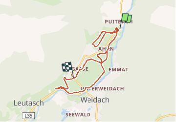

Longueur
9,1 km

Altitude max
1125 m

Dénivelé positif
108 m
Km-Effort
10,5 km

Altitude min
1088 m

Dénivelé négatif
90 m
Boucle
Non
Date de création :
2020-02-18 11:59:12.825
Dernière modification :
2020-02-18 13:45:16.065
1h45
Difficulté : Facile

Application GPS de randonnée GRATUITE
 SityTrail
IGN / Instituts géographiques
SityTrail Plus
Le monde est à vous
À propos
Randonnée Ski de fond de 9,1 km à découvrir à Tyrol, Bezirk Innsbruck-Land, Gemeinde Leutasch. Cette randonnée est proposée par Bernardb44.
Localisation
Pays :
Autriche
Région :
Tyrol
Département/Province :
Bezirk Innsbruck-Land
Commune :
Gemeinde Leutasch
Localité :
Unknown
Départ:(Dec)
Départ:(UTM)
664117 ; 5250572 (32T) N.
Commentaires